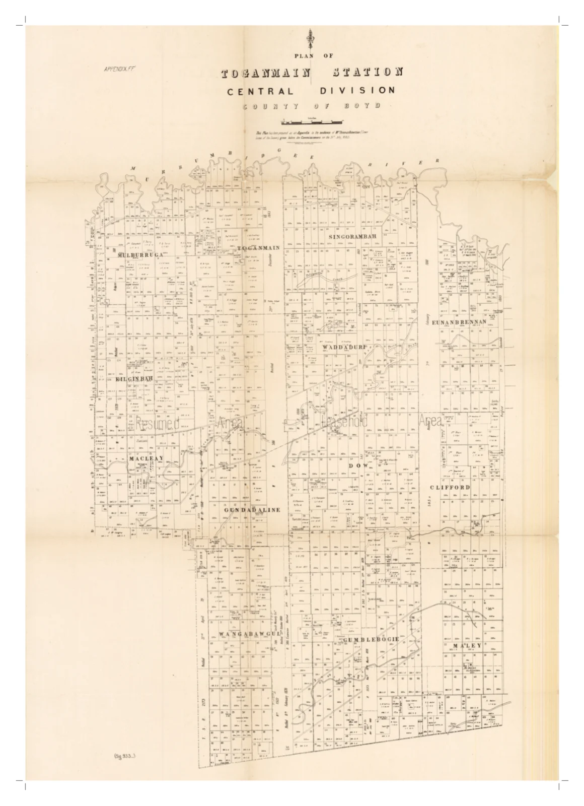
Filed away in the back pages of a colonial parliamentary report, marked simply ‘Appendix FF,’ is a hand-drawn plan of Toganmain Station — every paddock, boundary and bend of the Murrumbidgee laid out for a Royal Commission trying to work out where the colony’s water was going, and where it should go next. It was tabled by Thomas Robertson, Toganmain’s pastoral lessee, when he gave evidence in Sydney on 31 July 1885.
By the mid-1880s the Riverina had shown both extremes of the weather within a few short years — drought low enough to stop the rivers running, and floods wide enough to drown whole paddocks. In 1884 the New South Wales Government appointed a Royal Commission on the Conservation of Water, chaired by William John Lyne, to work out what could actually be done about it: how rivers like the Murray and Murrumbidgee might be regulated, where canals and weirs could go, and how irrigation might change pastoral country that had, until then, lived or died on rainfall alone.
Toganmain’s evidence came from its lessee, Thomas Robertson, who appeared before the Commissioners in Sydney on 31 July 1885. He spoke to the practical end of the question — the water conservation work already under way on the station, its improvements, and what a run of this size along the lower Murrumbidgee, between Hay and Narrandera, actually needed to keep stock and country going through the dry years. To help the Commissioners picture exactly what he meant, he tabled the plan above: paddock by paddock, from Mulburruga and Bilginbah in the west across to Eunanbrennan and Clifford in the east, showing the creeks, billabongs, dams, tanks and cutting sites that made up the station’s water system, along with the ‘Resumed Area’ and ‘Leasehold Area’ that, by the 1880s, split most Riverina runs in two.
The Commission’s work made regular news over the following two years. Papers as far apart as Maitland, Sydney and Wagga Wagga followed its engineer, H. G. McKinney, as he reported back on where large-scale irrigation might actually be made to work — none of it naming Toganmain directly, but all of it giving a sense of the scale of thinking Robertson’s evidence was feeding into. By September 1886 McKinney was recommending a weir across the Murrumbidgee at the foot of the Malebo Range, six miles from Wagga, to feed canals along both banks of the river as far as the One Tree Plain and the Old Man Plain. His final report the following year matched it with a scheme on the Murray, fed by a weir near Jindera, and a branch canal built for the sole purpose of keeping Lake Urana full, so its natural basin could double as a giant storage reservoir. Little of it was ever built at anything like this scale — large-scale irrigation on the Murrumbidgee was still a generation away, and wouldn’t arrive until the Burrinjuck Dam and the Murrumbidgee Irrigation Area, in the 1910s. But it shows what Robertson’s evidence, and his map of Toganmain, were feeding into: not just one station’s water needs, but a colony trying to work out how to hold onto water at all.
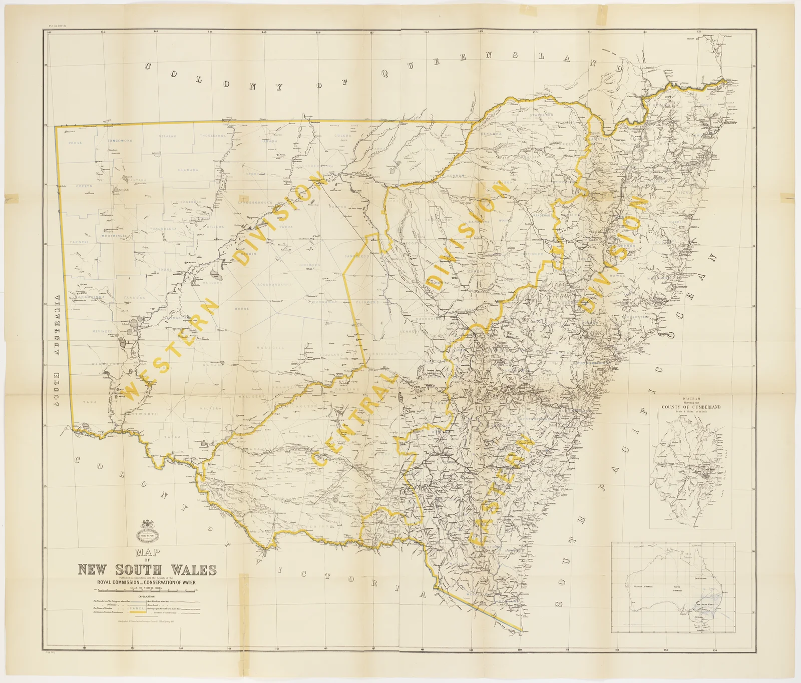
The Commission’s final report, when it appeared in 1887, came with its own map of the colony — the same ‘Central Division, County of Boyd’ classification that appears at the top of Robertson’s own plan, here shown as just one corner of a colony-wide carve-up into Western, Central and Eastern Divisions. Toganmain itself is far too small to appear by name at this scale — but it sits somewhere in that pale expanse of the Central Division, in the country between Hay and Narrandera.
Robertson’s family held the Toganmain lease for 121 years, from 1867 to 1988 — so this evidence, and this map, come from early in that long stewardship, not far past its first two decades. A century and a half later, the map has found its way back to the property it describes: digitised from the original parliamentary report, and laid out here paddock by paddock, the same names — Mulburruga, Waddadurf, Gumblebogie — that Robertson himself would have known by heart.